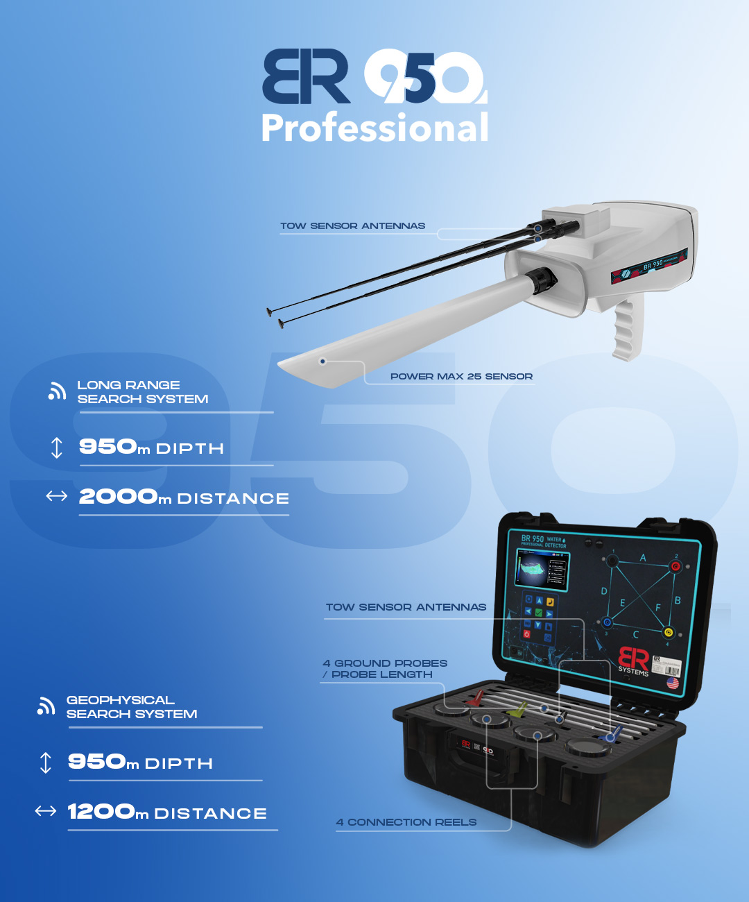
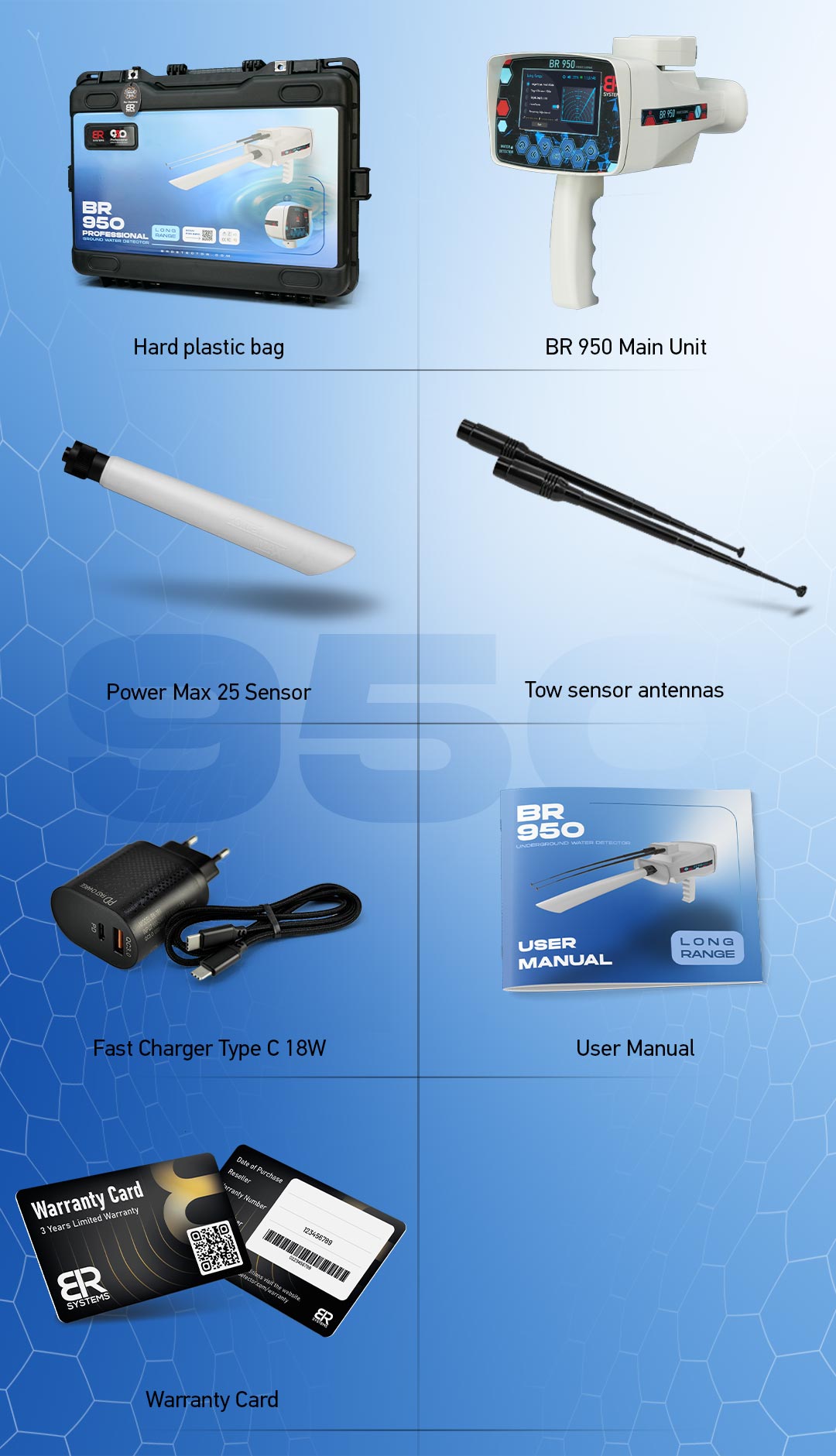
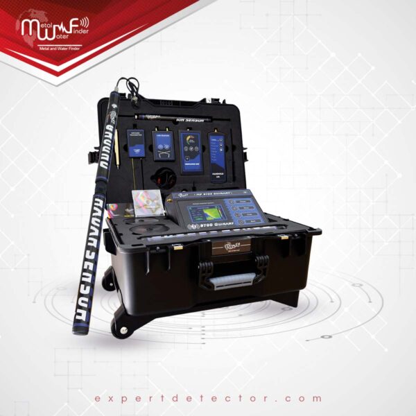
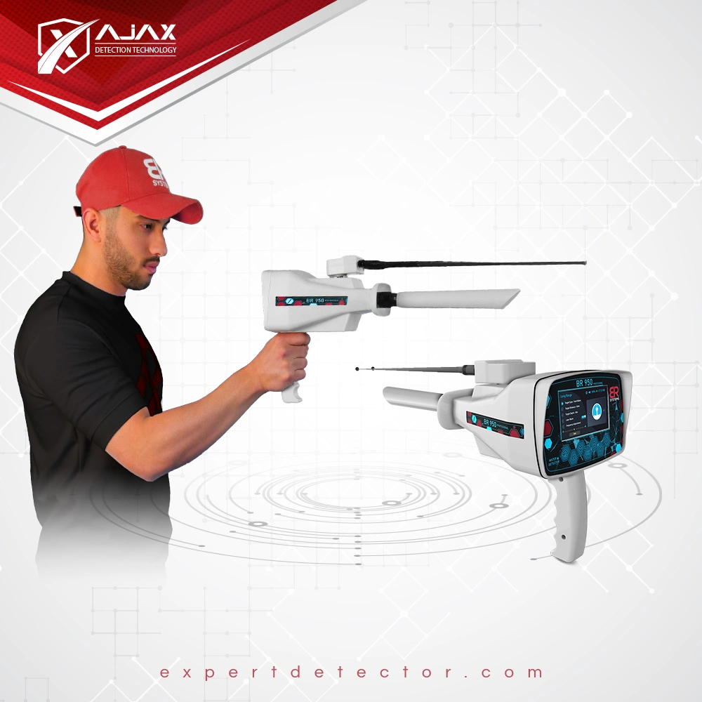
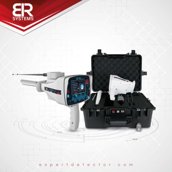
• [email protected]
Login / Register
  • العربية
  • العربية
Expert Detectors
  • Home
  • About us
  • Our Devices
    • The Best Gold & Metal Detectors
    • Treasures & Gold Nuggets Detectors
    • Diamond & Gemstone Detectors
    • Groundwater Detectors
    • Ground Imaging System
    • Long-Range Search System
    • Electromagnetic System Detectors
    • Ionic Detection System
    • Geophysical Survey System
    • Global brands
  • Our Services
  • Contact Us
0 items / $0
Expert Detectors
0 items / $0
Menu

Expert center for gold and metal detectors

Expert center for gold and metal detectors

BR 950 Professional Underground water detector
Click to enlarge
Home Shop Groundwater detectors BR 950 Professional
Ajax Omega Underground water detector
Ajax Omega $5,100
Back to products
BR 950 Underground water detector
BR 950 $2,750

BR 950 Professional

$7,600

The device detects: (freshwater – mineral water – saltwater – all types of water)
Device systems: Long Range Locator – Geophysical Search System
BR 950 Profissional Underground water and Well Detector is the latest scientific device that contains advanced detection and research systems to explore groundwater locations, wells, and groundwater basins.
We can say that we now have the best and most accurate advanced scientific device that helps land owners and prospection companies to eliminate water scarcity and work to take an advantage of the groundwater wealth in all regions of the world.

Manufacturer BR Systems
Country of Origin USA
Maximum Depth 1200M
Long Distance 2000M
Systems 2 detection systems
Categories: Geophysical Survey System, Groundwater detectors
  • Description
  • Features
  • Technical specifications
  • Systems
  • Accessories
Description

BR 950 PROFESSIONAL

  • BR Systems has for many years been producing groundwater detectors and working on developing and modernizing them to provide the best for its users all over the world.
  • It is flexible in detecting groundwater, and this device has been tested in many regions around the world on a range of different soils and environments, and we have obtained positive results of up to 95%.
  • This advanced device is capable of identifying and discovering all types of groundwater and determining the appropriate place for drilling in addition to its ability to separate and distinguish between shallow sedimentary water and deep groundwater, with a percentage showing the detected water thrust with accurate results that exceed the results of similar devices available in the market.

  • This device was designed and produced after long and deep studies to choose the appropriate mechanical and electronic components that allow the user to move, operate the device and work with it easily and to achieve a high performance and speed in detecting the target by using its modern techniques that achieve the most accurate results in external detection operations within all types of terrain and different climates.
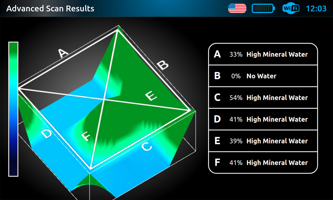
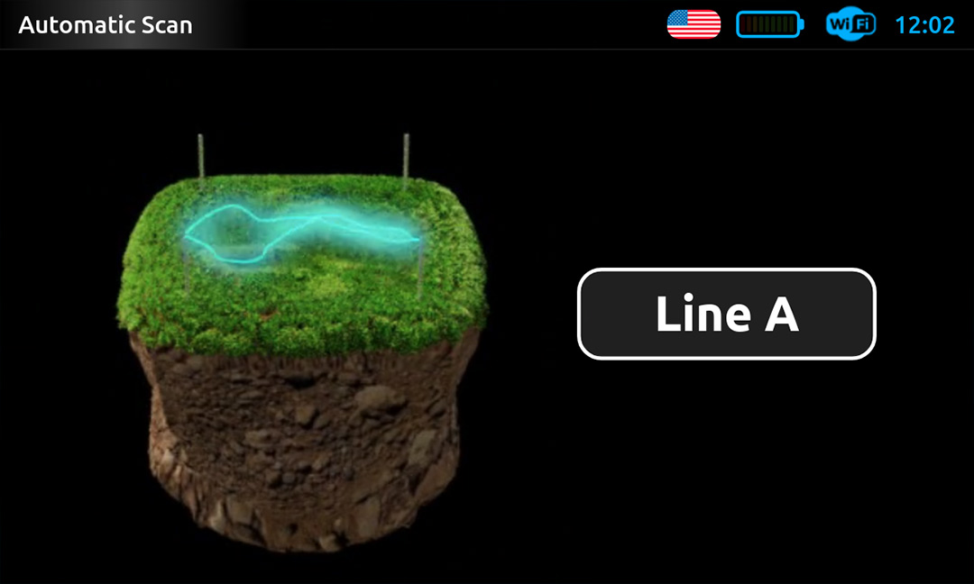
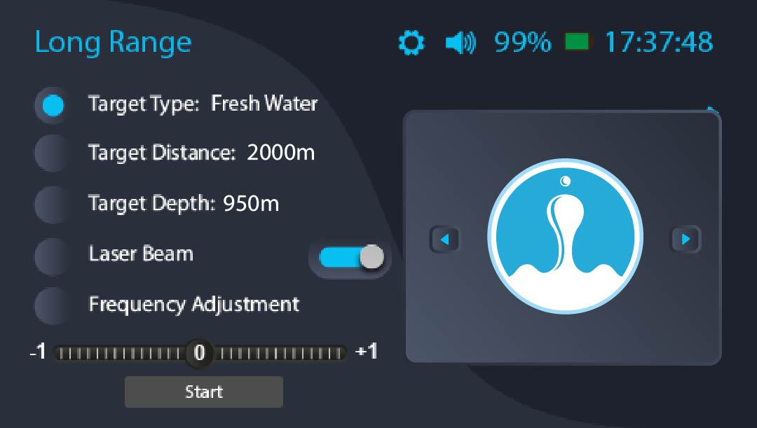
  • Advanced detection systems: This new detector has been equipped with 4 detection systems that can provide sufficient and accurate information about the locations of water within the explored area, in addition to making a 3D photogrammetric scans showing the location of water in detail and determining its path and knowing the strength and movement of water flow in the discovered place with an indication of the detected water type like fresh, salty or mineral, in a detailed manner and in special proportions that appear on the device screen automatically.
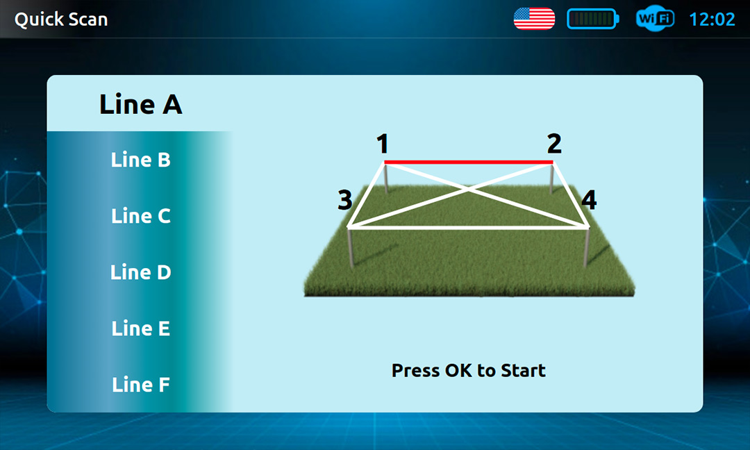
  • The BR 950 Profissional device is equipped with a modern and easy interface and drivers through which the user can operate the device’s systems and work on them quite easily according to the instructions within the systems, very clear about the methods of operation and the correct connection of the parts of the device and to ensure an accurate result in prospecting operations and avoiding operation and negative conduction.
  • This device is provided with an external application installed on a tablet computer, through which we can view the search results in full, in addition to a 3D drawing of the targets and store them directly, and the connection between the tablet and the device is done through the Wi-Fi network (called BR 950 Profissional-Password: brsystems) of the device automatically. (Without the need for the Internet), we open the application and review the results.
Features

BR 950 PROFESSIONAL Features

  • device supports working with 4 actual detection systems: (LRL – automatic scan – Quick Scan – ADVANCED 3D SCAN) All these systems have been developed and supported by all modern technologies
  • Specialized for the detection of groundwater, wells and underground river water
  • This device is integrated with 4 advanced main detection systems to be an integrated exploration machine for all groundwater detection operations.
  • high speed in locating the surrounding targets and verifying them with an accuracy of up to 99%, through the actual 4 detection systems in the device
  • A 3D scan showing the location of the water in detail, determining its path, knowing the strength and movement of the water flow in the discovered location, indicating and clarification of the quality of the detected water if it was fresh or salt water, in detail and in special proportions that appear on the device screen automatically.
  • This device is provided with an external application installed on a tablet computer, through which we can view the search results in full, in addition to a 3D drawing of the targets and store them directly, and the connection between the tablet and the device is done through the Wi-Fi network (called BR 950 Profissional-Password: brsystems) of the device automatically. (Without the need for the Internet), we open the application and review the results.
  • Determining the water force automatically on the screen via a special indicator and at the percentage rate %.
  • advantage of comprehensive discrimination between the types of water detected.
  • Determining the depth of water automatically detected on the screen.
  • Maximum search depth in geophysical detection systems: 1200 m below the surface.
  • Maximum search depth in the long-range detection system LRL: 950 m below the surface.
  • frontal search area in the long-range detection system LRL: 2000 m circular
  • possibility of determining the quality of the water to be detected before starting the search and restricting other types of water (LRL system).
  • new BRF signal filtering system to filter the transmitting and receiving signals and avoiding any interference near the exploration site and focusing only on the real targets surrounding the place.
  • This device is supported by B.U.M . automatic detection technology.
  • G.L.Y . Laser Guidance Technology.
  • new SRT technology for geophysical detection systems developed by BR System, which works on probing and measuring the electrical resistance of the soil to determine and discover the places of water underground.
  • Changing the frequency of the HZ signal, and this feature allows giving a higher detection efficiency and strength in hard and dry ground when the signal is increased and it can be raised from 30 HZ to 150 HZ.
  • Choosing the type of soil to be detected before starting the search.
  • Sensitivity adjustment: the sensitivity of the transmitted signal can be raised to increase the electrical signal transmission in the soil, through special values that appear on the screen, which can be increased or decreased according to the need for the density of the water to be detected.
  • Determining the distance between the search poles automatically (from 5 m to 50 m), which is a new feature in the world of geophysical devices for water detection. This feature ensures that the results are more accurate than the traditional method.
  • device supports 10 international languages: English – French – German – Spanish – Arabic – Turkish – Persian – Russian – Urdu – Italian.
  • Perfectly new and fashionable mechanical design and convenient size.
  • Store all scans on the device memory automatically with the possibility of deleting them in the future.
  • Ease of handling the device / The method of working and using this device has been prepared in line with the overwhelming majority of users, with the possibility and ease of use of the device by ordinary, inexperienced people.
  • device is provided with modern and smart interfaces and operating programs with the ability to save settings, and show the necessary alerts when needed, in addition to the electronic guidance support that appears in the form of messages on the device screen.
  • device was provided with modern, high-definition colored screens suitable for all day and night operating times.
  • Standard time to charge and use – This product supports quick charge feature.
  • Device screen brightness control / Device sound level control.
  • device screen supports the time clock and can be set based on the region + showing the percentage of the battery and the charging signal.
  • A smart and easy-to-handle control panel that contains the keys and buttons of the device.
  • A hard plastic bag of 2 anti-dust and reinforced with reinforced sponge to save the device.
Technical specifications

Technical specifications of geophysical detection systems

Processor type ARM 1.5 GHz / Microprocessor
Display inch TFT high resolution 800 x 4805
Operating voltage 12v
Power consumption 350 mA – 500 mA
Battery charging hours 4.5-5 hours
Battery working hours 6 hours
Battery output 12 V – 3 A
Storage 16 GB
Charger 12.6 V – 2 A
Weight kg 7.5
Dimensions X 32 X 20 cm 40
Operating temperature -20 to +55 degrees Celsius
Storage temperature from -10 to +40 degrees Celsius

Technical Specifications Of LRL Detection System

Processor type MICROCHIP PIC32
Display 4.3 inch display with a resolution of 480 x 272 pixels / 16.7 million colors / 400 cd illumination
Battery Li-ion battery – 7800 mAh – V 3.7 / 20 continuous working hours
Battery charging hours 3.5 hours
Device charger specifications USB charger with Type-C 18w
Languages English – French – German – Spanish – Turkish – Arabic
Bag dimensions 530mm x 400mm x 228mm
Total weight in the bag 5030 grams approx
The main unit of the device 830g Weight when assembled
Weight of the device when fully installed 1.000 kg
Operating temperature -20 to +55 degrees Celsius
Storage temperature from -10 to +40 degrees Celsius
Systems

BR 950 professional systems

1- Advanced 3D Scan

  • This system, developed exclusively by BR Systems, works on a new technology to probe and measure the electrical resistance of the soil (SRT) to determine and discover the places of groundwater. This system has been completely modernized so that it can detect water very accurately with the results shown on the screen and immediately, while showing the type, abundance and depth of the detected water. The discovered location with instant and automatic storage of the detected scans within the device’s memory.
  • Maximum search depth: 1200 meters below the surface.
  • Distinguishing between the types of detected water: This system automatically shows the quality of the detected water after completing the search process and it appears on the screen (fresh water – mineral water – salt water – highly salinity)
  • 3D drawing of the target: This system shows an illustration of the target in three dimensions, and the image of the detected target can be moved in several directions to check its size.
  • This device is provided with an external application installed on a tablet computer, through which we can view the search results in full, in addition to a 3D drawing of the targets and store them directly, and the connection between the tablet and the device is done through the Wi-Fi network (called BR 950 Profissional-Password: brsystems) of the device automatically. (Without the need for the Internet), we open the application and review the results.
  • Determining the water force automatically on the screen via a special indicator and at a percentage % rate.
  • Show digital indicators interacting with all detected signals
  • Permanently display interactive audio indicators when running and at the start and end of the search, with the ability to adjust and change them.
  • Show the percentage of water salinity discovered through the newly developed PPM scientific analysis technique.
  • Determining the depth of the water detected on the screen, and the depth appears automatically on the display screen immediately after completing the search process.
  • Changing the frequency of the HZ signal, and this feature allows giving a higher detection efficiency and strength in hard and dry land when the signal is increased, and it can be raised from 30 HZ to 150 HZ.
  • Choosing the type of soil to be detected before starting the search.
  • Sensitivity adjustment: the sensitivity of the transmitted signal can be raised to increase the electrical signal transmission in the soil, through special values that appear on the screen, which can be increased or decreased according to the need for the density of the water to be detected.
  • Determining the distance between the search poles automatically (from 5 m to 50 m), which is a new feature in the world of geophysical devices for water detection, as the distance between the search poles can be determined through the device program before starting the search process to fully correspond with the distance actually used on the ground. This feature ensures that the results are more accurate than the traditional method.

2- Geophysical System (Quick Scan)

  • This system works through the SRT technology developed by BR Systems, which works on probing and measuring the electrical resistances of the soil to locate and discover the places of water underground.
  • The Quick Scan system is characterized by a quick search and scan within a narrow area by planting only two poles in the soil without the need for 4 poles.
  • After connecting 2 of the electrodes in the soil, we choose the search line compatible with these electrodes, for example, the search line A, which is compatible with pole 1 and 2, where the device will scan only within this line and show the result on the screen and this feature can be used when needed To make a quick scans in a narrow place, or after using the automatic search system, to limit the location of water within 1 m2.
  • Distinguishing between the types of detected water, this system automatically shows the type of the detected water after completing the search process and it appears on the screen (fresh water – mineral water – salt water – highly salinity)
  • Maximum search depth: 1200 meters below the surface.
  • Determining the water pushing force automatically on the screen via a special indicator and at a percentage rate %.
  • Show digital indicators interacting with all detected signals
  • Permanently display interactive audio indicators when running and at the start and end of the search, with the ability to adjust and change them.
  • Show the percentage of water salinity discovered through the newly developed PPM scientific analysis technique.
  • Determining the depth of the water detected on the screen and it appears automatically on the display screen after completing the search process.

3- Geophysical System (Automatic Search)

  • The automatic search system in this device has been developed and integrated with modern software and techniques to complete the detection process at high speed and provide detailed automatic results on the screen for the locations of water, its density, depths and salinity.
  • Through this system, we can conduct a comprehensive search for a specific area by connecting 4 electrodes in the soil and connecting them with the device through special connection cables.
  • This system shows the search results directly on the screen after the completion of the scans process and gives a detailed report on the place that was scans and shows the locations of water with accurate identification and limitation of the target within 1 m2.
  • The scanning process in this system is through 6 different scanning lines A – B – C – D – E – F
  • Distinguishing between the types of detected water, this system automatically shows the type of the detected water after completing the search process and it appears in written form on the screen (fresh water – mineral water – salty water – highly saline)
  • Maximum search depth: 1200 meters below the surface.
  • Determining the water force automatically on the screen via a special indicator and at the rate %
  • Show digital indicators interacting with all detected signals
  • Show interactive audio indicators permanently when running and when searching starts and ends with the ability to adjust and change them.
  • Show the percentage of water salinity discovered through the newly developed PPM scientific analysis technique.
  • Determining the depth of the water detected on the screen and it appears automatically on the display screen after completing the search process.
Scan Methods ADVANCED 3D SCAN – Geophysical search system (Quick Scan) – Geophysical search system (automatic search)
Depth 1200 meters
Electrodes Length 50 meters
Frequency 150 HZ
Scan Lines 6
Targets Fresh Water – Salty Water – Mineral Water – High Salinity
Soil Types Mineral – sandy – clay – mixed – natural – rocky
Supported Techniques SRT . Soil Electrical Resistivity Measurement Technology
PPM . Water Salinity Measuring Technology

4- Long Range Locator (LRL) System

  • horizontal sensing technology (LRL) in the BR 950 Profissionalfessional is based on scientific foundations and modern technologies that were recently developed and designed by BR Systems, as it is characterized by accuracy and high efficiency in detecting potential targets in the surrounding area in a short time. Through this system, you can choose the type of water to be detected (fresh water – mineral water – salt water – all types of water) and the device will automatically start directing you towards the strongest water points in the area until it connects you to the target center in rapidly.
  • This system is characterized by the speed of tracking targets from long distances of up to 2000 m circular, and this is done with high detection accuracy and correct orientation, and it can work in all types of different terrain and on all types of soil, whether arid or wet.

    BRF technology new signal filter technique :

    This system is equipped with a new technology to filter the transmitted and received signals BRF to maintain a precise and pure signal away from any interference caused by ground radiation emanating from the rocks and the natural mineral interference in the soil. Determining the real targets in the area with great accuracy and staying away from any mineralization or radiation present in it, and this also enables the use of this system in all rugged areas and different terrain at all times.

    LRL System features :

    • The possibility of determining the quality of the water to be detected before starting the search and restricting other types of water.
    • The depth of this system reaches 950 m underground with the ability to determine the maximum depth to be reached.
    • The maximum search range is 2000 circular meters with the ability to select on several levels.
    • This system is supported by B.U.M . automatic monitoring technology.
    • The system supports radar signals on the screen that show that the system is in use and running.
    • The system supports audio technology accompanying the radar signals on the screen.
    • The laser guidance technology G.L.Y to the system, which in turn shows the user the direction of the target and guides it until reaching the target center.
    • The possibility of changing the frequency from -25 Hz to + 25 Hz and this technology is more useful for users who have worked on the device for a longer period.
    • List of targets detected by the system: fresh water – mineral water – salt water – all types of water at one time.
    • The possibility of controlling the change of the required maximum depth from 25 m up to 950 m based on the user’s desire.
    • The possibility of controlling the change of the front range of the detection from 100 m up to 2000 m circular based on the user’s desire.
    Depth 950 m
    Distance 2000 m circular
    Targets Fresh water – mineral water – salt water – all types of water
    Supported Techniques BUM . automatic monitoring technology
    BRF . Signal Filter Technology
    GLY GUIDANCE LASER TECHNOLOGY
Accessories

BR 950 Professional Device Accessories

The Geophysical System Portfolio Includes


Long Range Locator System Bag Includes


The Geophysical System Portfolio Includes


Long Range Locator System Bag Includes

Related products

BR 800 P gold detector

BR 800 P

$7,300
Manufacture USA
Depth 50m
Distance 2000m
Read more
WF 303 GH Underground water detector

WF 303 GH

$5,180
Manufacture USA
Depth 1000m
Distance 2000m
Read more
MF 1500 Smart gold detector

MF 1500 Smart

$4,700
Manufacture USA
Depth 40m
Distance 2000m
Read more
MF 9700 Q gold detector

MF 9700 Q

$9,900
Manufacture USA
Depth 70M
Distance 2000M
Read more
WF 101 III Pro underground water detector

WF 101 III (Pro)

$3,250
Manufacture USA
Depth 800m
Distance 2500m
Read more

Hydro Tracker

$7,400
Manufacture USA
Depth 1000M
Distance 0
Read more
BR 700 pro underground water detector

BR 700 Pro

$3,000
Manufacture USA
Depth 700M
Distance 0
Read more
Ajax Omega Underground water detector

Ajax Omega

$5,100
Manufacture USA
Depth 500M
Distance 2850M
Read more
MWF Navvy Underground water detector

Navvy

$2,250
Manufacture USA
Depth 500M
Distance 2000M
Read more
BR 950 Underground water detector

BR 950

$2,750
Manufacture USA
Depth 950M
Distance 2000M
Read more
Contact Us
  • Aksaray Mah - Fındıkzade - Near of Ramada Hotel - NO:70/5 - Fatih/Istanbul
  • +90 506 101 90 90
  • +90 535 033 63 88
  • [email protected]
Expert Detectors
  • Treasures and gold nuggets detectors
  • Ground Imaging System
  • Electromagnetic system detectors
  • Long-range search system
  • Diamond and gemstone detectors
  • Groundwater detectors
Best Selling Detectors
  • Gold Step Pro Max
  • Ajax Primero
  • Ajax Ares
  • Royal analyzer pro 6000
  • Ajax Alpha
  • Invenio Pro
Copyrights © 2024 Expert gold and metal detectors.
Cargo logos
Close
  • Home
  • About us
  • Our Devices
    • The Best Gold & Metal Detectors
    • Treasures & Gold Nuggets Detectors
    • Diamond & Gemstone Detectors
    • Groundwater Detectors
    • Ground Imaging System
    • Long-Range Search System
    • Electromagnetic System Detectors
    • Ionic Detection System
    • Geophysical Survey System
    • Global brands
  • Our Services
  • Contact Us
  • Login / Register